There are many reasons why soil scientists dig soil pits. They all revolve around collecting information to address a question or a management problem. And sometimes they hold more questions than answers.

In the summer of 2017, I was working as a range technician for the U.S. Forest Service, Bighorn National Forest in northern Wyoming. In early August, via horses, my boss and I rode to an area known as “The Bowl” near Bald Ridge. Our main purpose there was to collect a camera trap that was monitoring animal populations browsing on the willows in this alpine meadow. We also wanted to dig a soil pit to practice our soil description skills. The soils in Bighorn impact the quality of the natural forage grasses that support grazing animals and the water quality of this National Forest. The Bowl is at about 10,000 feet in elevation, which is why we rode our horses in this wilderness, with all our equipment.
After collecting the camera, we walked up towards Bald Ridge. We found a few gullies and erosional features around the foot slope of the ridge as it came down into The Bowl.

The gullies provided us an opportunity to save time and collect information about the soils of this mountain area. We used our shovel to clean a nice face on the side of one of the gullies. We were curious why the soils on this slope were experiencing the erosion issues as this gulley exhibits.
The upper portion of the soil profile was a sandy loam texture throughout. Clay content increases towards the bottom. The horizon boundaries are marked with fir twigs in the center of the face.
At the bottom of this soil profile (about 1 meter below the soil surface), you can see a very distinct change in color within this layer – or soil horizon. This dramatic change in color indicates a change in organic matter content. In addition, the texture changed almost instantly from a sandy loam to a silt loam. The most unexpected thing we found in the lower layer were pieces of wood charcoal!
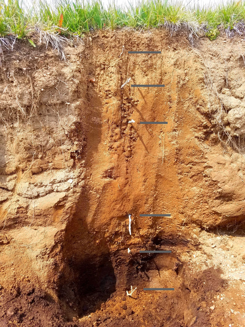
Such a change in texture and soil color normally means that this bottom layer of soil was once at the top and was then buried. This begs the following questions, with no real answers:
- What might these abrupt changes and presence of charcoal tell us about the history of this meadow?
- Was this area once forested and then burned?
- What happened to bury this charcoal so deep?
- How long ago might this have occurred?
Another thought is that this could be an archaeological site. Perhaps there was a hearth for past residents? And then, over time, the hearth, and its charcoal were buried. This is a possibility. However, such dramatic changes in soil texture, color, and structure, makes me lean more towards this being a buried profile.
I have seen other buried horizons like it in areas of Utah and Colorado.
This soil profile may have been buried due to some of the same reasons that the area is now experiencing some erosion. This alpine ridge is a very prominent feature and collects large snow packs along the ridge during the winter. Such snow packs can turn into perennial snow or ice fields, given the right conditions. Though they aren’t glaciers, they can still grind at the bedrock and make sediments ready to transport downslope when the snow and ice melts. This may have been what happened in the past. There may have been a large snow-field along the top of Bald Ridge that melted and transported large quantities of sediment down into the Bowl and started the soil formation process anew. Now, as the snow packs that form on Bald Ridge melt completely, the water they release flows downslope and cuts down into the soil – demonstrating the dynamic nature of alpine soils.
As with many sciences, digging a soil pit can leave us with more questions than answers. But, we still collected data, photos, and the location of this pit. We exchanged this information with the Natural Resource Conservation Service (NRCS). Soil scientists in the region may revisit the site in the future and conduct a more thorough description and come to their professional conclusions.
All in all, soils can hold information about the history of a landscape, whether that be the history of humans or the history of disturbance events that an area has experienced over time. Such features make them important to study and learn from. This is one of many reasons that soil scientists dig soil pits and do profile descriptions – and the journey associated with the work often is just as thrilling as the work itself!
Ryan Schroeder, Colorado State University
To receive notices about future blogs, be sure to subscribe to Soils Matter by clicking on the Follow button on the upper right! Explore more on our webpage About Soils. There you will find more information about Soil Basics, Community Gardens, Green Infrastructure, Green Roofs, Soil Contaminants, materials for Teachers and more.

Interesting article. Why not just dig a second soil pit a little ways away to rule out the archaeological site possibility?
The blogger was up there for a different intent and didn’t have time to do this step. The blog states that sometimes questions are left unanswered – for now. svf